Apopka Expressway Map

Advertising
Advertising

Exits Map For The Apopka Expressway

This map of the Apopka Expressway displays markers for exits and tolling points, which you can select to get a close-up map of that point of interest or location.

The points-of-interest shown on this map are also listed below.

See below for more comprehensive information about the Apopka Expressway

Advertising
Advertising
Static map a segment of the Apopka Expressway

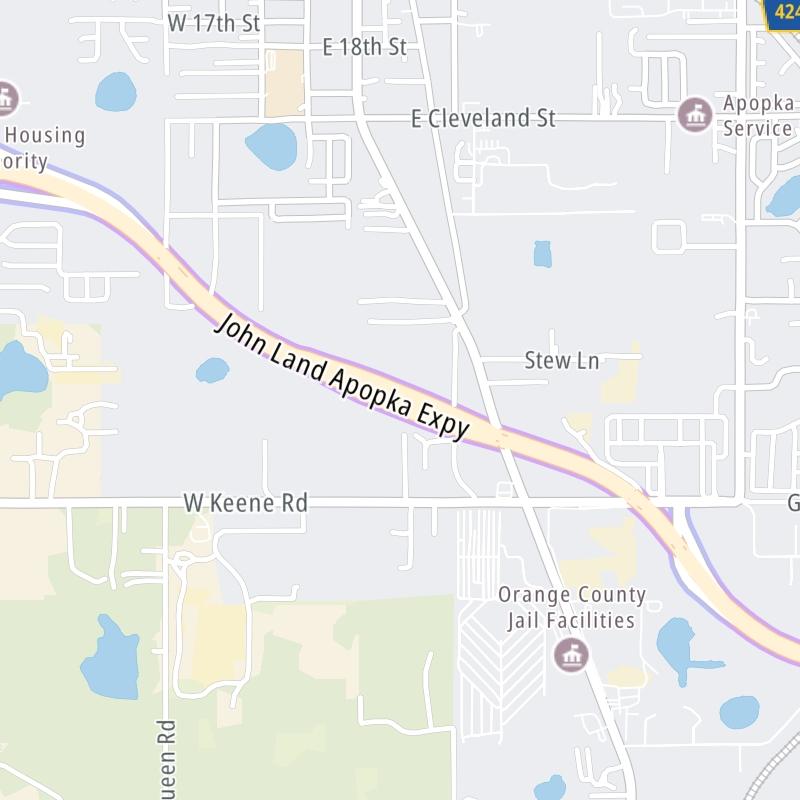
A Quick Look At The Apopka Expressway

This local toll road serves several key cities, including Apopka, Lockhart, Ocoee, and Orlando.

The fixed map seen here presents a quick view of The Apopka Expressway and surrounding area. The fully-interactive map of The Apopka Expressway abvoe includes linked markers. You may resize and reposition the interactive map to orient the road in relation to other landmarks.

There is also a complete list of exits below.

View Map Exit / POI List

Advertising
Advertising

What Does It Cost To Use The Apopka Expressway?

Tolls For Cars, SUVs, Pickups, etc.

This data is coming soon.

Transponders You Can Use

For drivers paying with a transponder, the following passes will work on the Apopka Expressway

  • epass
  • epass xtra
  • uni
  • sunpass pro
  • sunpass
  • e-zpass
  • i-pass
  • peach pass
  • quick pass

Learn about transponders and accounts in Florida.

View MapAll Tolls / Calculator ▸

Our new toll and trip calculator is being constructed. For most roads, you can still use the legacy calculator for current, accurate tolls.

Discover Florida Attractions

Turnpikes.com has partnered with Tiqets.com to bring you these excusive deals on attractions!

Advertising
Advertising

Travel Alerts

No alerts to display at this time.

Exit/POI List For The Apopka Expressway

Selecting an exit or other location opens a separate map with locations of available gas, EV charging, fast-food and other dining options. Current weather and driving conditions will also be shown.

SR 429 Connector / U.S. Hwy 441 — Apopka

Note(s): W Orange Blossom Trail

GPS 28.698266000 X -81.559208000

CFX Central Florida Expressway Authority manages this segment.

View Map & Info

Exit 4BSR 429 / Wekiva Pkwy — Apopka

Note(s): South for SR 429 / Western Beltway

GPS 28.652251000 X -81.542027000

CFX Central Florida Expressway Authority manages this segment.

View Map & Info

Exit 4ASR 451 — Apopka

Note(s): None.

GPS 28.653494000 X -81.530505000

CFX Central Florida Expressway Authority manages this segment.

View Map & Info

Exit 5Marden Rd — Apopka

Note(s): EB on / WB off only

GPS 28.652913000 X -81.525789000

CFX Central Florida Expressway Authority manages this segment.

View Map & Info

Coral Hills Mainline Plaza — Apopka

Note(s): Toll gantry and plaza

GPS 28.644110000 X -81.507468000

CFX Central Florida Expressway Authority manages this segment.

View Map & Info

Exit 6Keene Rd — Apopka

Note(s): EB on / WB off only

GPS 28.638608000 X -81.495562000

CFX Central Florida Expressway Authority manages this segment.

View Map & Info

Exit 8Hiawassee Rd — Apopka

Note(s): None.

GPS 28.634173000 X -81.476288000

CFX Central Florida Expressway Authority manages this segment.

View Map & Info

Exit 9U.S. Hwy 441 — Lockhart

Note(s): None.

GPS 28.633836000 X -81.452414000

CFX Central Florida Expressway Authority manages this segment.

View Map & Info

Bear Lake Rd / Rose Ave — Lockhart

Note(s): SR 414 continues east as Maitland Blvd

GPS 28.639894000 X -81.443601000

CFX Central Florida Expressway Authority manages this segment.

View Map & Info

Advertising
Advertising

EXPLORE FLORIDA

Journey to key destinations around and adjacent to Florida!

Map Of This Region ▹

Communities in this metro area include Destin, Pensacola Beach, Pensacola, Niceville, and Gulf Breeze.

Individual toll maps for this region are listed below.

Map Of This Region ▹

Communities in this metro area include Jacksonville and Middleburg.

Individual toll maps for this region are listed below.

Map Of This Region ▹

Communities in this metro area include Apopka, Cocoa, Kissimmee, Lake Buena Vista, Orlando, Saint Cloud, Sanford, Titusville, Melbourne, Poinciana, and Mount Dora.

Individual toll maps for this region are listed below.

Map Of This Region ▹

Communities in this metro area include Bradenton, Brandon, Saint Petersburg, Spring Hill, and Tampa.

Individual toll maps for this region are listed below.

Map Of This Region ▹

Communities in this metro area include Fort Pierce, Port Saint Lucie, Stuart, and Vero Beach.

Individual toll maps for this region are listed below.

Map Of This Region ▹

Communities in this metro area include Fort Lauderdale, Pompano Beach, Hialeah, Opa Locka, Homestead, Kendall, Key Largo, Miramar, Miami, Hollywood, Sunrise, Boca Raton, Delray Beach, West Palm Beach, Jupiter, Davie, Coral Springs, Lake Worth, and Boynton Beach.

Individual toll maps for this region are listed below.

Map Of This Region ▹

Communities in this metro area include Fort Myers, Naples, and Cape Coral.

Individual toll maps for this region are listed below.

Map Of This Region ▹

Communities in this metro area include Tallahassee, Quincy, Midway, and Fort Braden.

Individual toll maps for this region are listed below.

tallahassee-state capital

Roads Within Region

Map Of This Region ▹

Map Of This Region ▹

Communities in this metro area include Mobile, Daphne, Dauphin Island, Chickasaw, and Spanish Fort.

Individual toll maps for this region are listed below.

beaches-gulf coast

Roads Within Region

Map Of This Region ▹

Advertising
Advertising
Turnpikes.com is proud to partner with the following: